




















THE TAKEAWAY
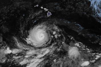
Major Category 4 Hurricane Lowell is generally maintaining its westward tracking, but its future track, indicating a northward turn come this weekend, is putting Hawaii on high alert for potential direct impacts.
An upper-level low will develop north of the Hawaiian Islands. This will erode the ridge, causing Lowell to slow down further and turn sharply northward.
If this trend continues, significant impacts will be possible in Hawaii early next week. Even a storm passing west of the islands could bring huge waves and gusty winds to Kauaʻi.
BREWING SUPER EL NIÑO EXPECTED TO BE STRONGEST ANYONE ALIVE ON THE PLANET HAS EVER EXPERIENCED
According to the National Hurricane Center, large ocean swells from Lowell are already moving north toward the Hawaiian Islands. They noted that the swells are likely to cause life-threatening surf and rip current conditions.
Here is everything you need to know about Hurricane Lowell.
STRENGTHENING EL NIÑO COULD SHAKE UP FALL WEATHER ACROSS THE US. HERE’S WHAT TO EXPECT
HURRICANE, TROPICAL STORM WATCH VS. WARNING: WHY IT’S IMPORTANT TO KNOW THE DIFFERENCE
LATEST EXCLUSIVE ANALYSIS FROM HURRICANE SPECIALIST BRYAN NOCROSS
The post Track Hurricane Lowell: Path, forecast cone, spaghetti models, wind and more appeared first on Fox Weather