
 Classic designer bags")


A final round of significant severe weather is impacting over nearly 50 million people across eastern Oklahoma and the Ark-La-Tex region.
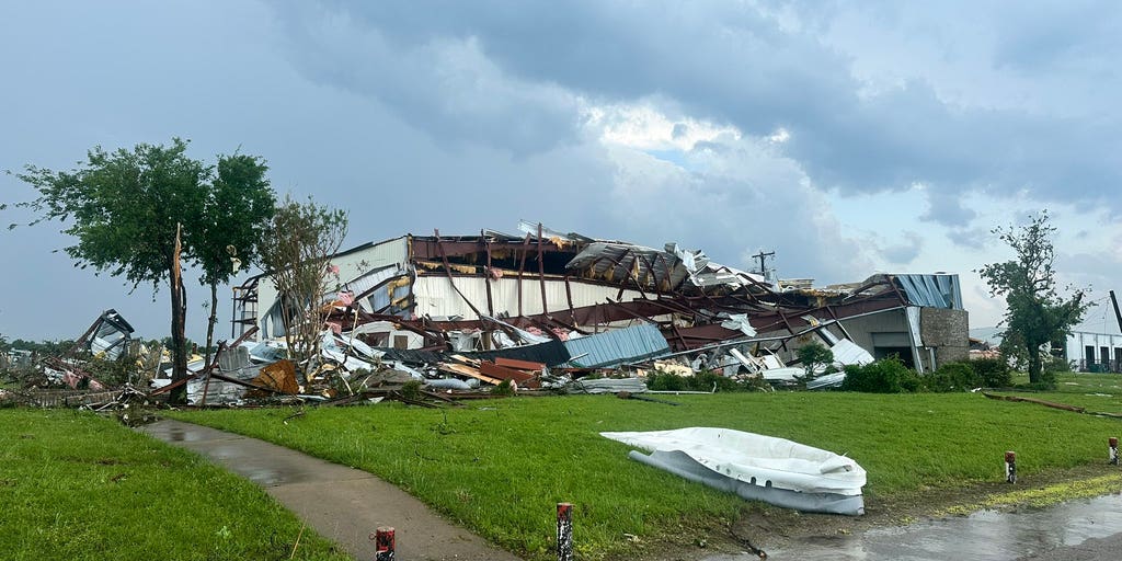
A confirmed tornado tore through Mineral Wells, Texas, around 6 p.m. ET and a lot of damage has already been reported.
A City of Mineral Wells official told FOX 4 that there is a large area of damage with some structures destroyed.
There are also reports of injuries, and those people have been taken to nearby hospitals for treatment, officials said.
First responders are at the scene assessing damage. City officials are asking residents to stay home and avoid traveling in the northeast area of the city.
"Keeping roadways clear is critical, so emergency personnel can do their jobs quickly and safely," the City of Mineral Wells, Texas, said on Facebook.
TORNADO SAFETY: THE SAFEST AREAS TO PROTECT YOURSELF AND WHY TO AVOID OVERPASSES
This marks the sixth consecutive day that NOAA's Storm Prediction Center (SPC) has issued at least a Level 3 out of 5 risk of severe thunderstorms for the Central U.S. and the South.
The outbreak began last Thursday, when a destructive EF-4 tornado struck Enid, Oklahoma, and continued into the weekend, when twisters killed at least two people in Runaway Bay, Texas late Saturday.
Large hail will be the main threat Tuesday afternoon when storms begin to fire over the Ark-La-Tex region, with hailstones larger than 2 inches in diameter possible.
A high Level 4 out of 5 risk was issued for the Dallas-Fort Worth area, marking an increased risk of large grapefruit-sized hail up to 4 inches in diameter, according to the SPC.
DEADLY WILDFIRES RAGING ACROSS GEORGIA AND FLORIDA FUELED BY DRY CONDITIONS AND HISTORIC DROUGHT
The Dallas and Shreveport, Louisiana, metro areas are included in this hail threat.
The SPC issued a Level 3 risk of severe thunderstorms Tuesday for parts of North Texas, southeastern Oklahoma, northern Louisiana, much of Arkansas and eastern Mississippi, as well as the Memphis, Tennessee, metro area.
The overall severe weather threat stretches across a corridor from the Big Bend of Texas through Kentucky.
According to the FOX Forecast Center, in addition to large hail, tornadoes will be possible with any supercell thunderstorms that form along a dryline — the boundary between dry air to the west and warm air from the Gulf to the east — that set up across Oklahoma and Texas.
WHAT IS A SUPERCELL THUNDERSTORM?
A cold front extending from Oklahoma through the Mississippi Valley will organize thunderstorms into clusters, where damaging wind gusts between 60 and 70 mph will become the main hazard.
SEE IT: DESTRUCTIVE STORMS SLAM TEXAS, LEAVING 2 DEAD AS SEVERE WEATHER SWEEPS REGION
Storms will shift east over Mississippi, Alabama, Tennessee and Georgia through the evening.
On Monday, the SPC issued a Level 4 out of 5 severe weather risk for southeast Missouri and southwest Illinois, warning of the potential for long-track tornadoes. Officials in Clinton County, Illinois, and Stone County, Arkansas, said tornadoes caused significant property damage, although no one was hurt or killed.
While a widespread tornado outbreak did not materialize, storms did take down power lines across parts of the Midwest and the South.
More than 300,000 customers were without power early Tuesday, with more than 50,000 in the dark in both Illinois and Michigan, according to PowerOutage.us. That number has since decreased.
Severe thunderstorms started early Monday, blasting through the Central Plains and the Midwest. Quarter-sized hail, heavy rain and wind gusts up to 70 mph were recorded moving through St. Louis and the rain triggered flash flooding in Kansas City, Missouri.
The Kansas City Fire Department performed at least 11 water rescues from normal high-water areas.
FLASH FLOODING PROMPTS WATER RESCUES ACROSS KANSAS CITY AS MIDWEST SLAMMED BY SEVERE THUNDERSTORMS
East of Kansas City, Monday morning storms damaged grain silos and neighborhoods near the city of Slater.
Damaging wind gusts pushed farther east, downing power lines in Glasgow, Missouri.
Images from the Glasgow Fire District also showed roofs torn off homes and municipal buildings.
Milwaukee Mayor Cavalier Johnson said strong wind gusts knocked down some trees and power lines. The city fire department received nearly 100 calls for downed tree limbs.
After a tornado warning early Monday, a second tornado-warned storm rolled over St. Louis just after 12:30 p.m. local time.
The National Weather Service (NWS) received hundreds of wind and hail reports as storms moved across Illinois and Indiana through the afternoon and into the evening.
The NWS issued a Particularly Dangerous Situation (PDS) warning as a tornado moved toward Carlyle, Illinois, shortly after 8 p.m.
MUCH-NEEDED RAIN TARGETS THE SOUTH, YET WORST DROUGHT ZONES WILL MISS OUT
The Clinton County Sheriff said late Monday there was "significant" damage across the county and emergency call centers were down during the storms.
Those same storms tore the siding off a large warehouse in nearby St. Clair County, Illinois, according to images from the county's emergency management agency.
The sheriff's office in Stone County, Arkansas, said a tornado caused abundant property damage just before 10:30 p.m and warned drivers to be aware of debris early Tuesday.
Stay with FOX Weather for the latest on the upcoming severe weather.
The post Texas city devastated by tornado damage as multi-day severe weather outbreak takes aim at millions appeared first on Fox Weather


